On 15 November 1988, Yasser Arafat officially recognized the existence of the State of Israel—affirming, as a corollary in accordance with UN Resolutions 181 and 242, that of the State of Palestine.footnote1 This declaration, followed by others, gave explicit ratification to what has been a fait accompli since 1947: the partition of Palestine. Arafat’s gesture was merely an acknowledgement of the undeniable truth of the situation: a nod to the inevitable. Nothing can negate the tangible phenomenon of the existence, between the Gulf of Aqaba and the southern Lebanese border, between Jordan and the Mediterranean Sea, of two peoples, each with a distinct and profound cultural identity: the Palestinian Arabs and the Israelis. No fusion of the two can reasonably be envisaged in the short or even the longer term. The eviction of the one by the other—as proclaimed in the PLO’s charter—is also clearly impossible. Arafat’s demagogic prophecy of the seventies—‘Israel will be another Vietnam’—has not materialized—or at least, not as he had hoped. But it is also hard to see biblical dreams of a Greater Israel becoming reality manu militari—whether through massive expulsions, or in any other way. There is certainly almost no chance of the slow phagocytic process by which the Vietnamese ingested the Khmers around the Mekong Delta in the sixteenth and seventeenth centuries: the Israelis lack the necessary numerical superiority for such an outcome. Israel’s attempts to colonize Judea and Samaria may indeed have made it ‘another Vietnam’—if not in the sense that Arafat intended. But the analogy stops there. Even with the massive wave of immigration from the former Soviet Union, it cannot hope to submerge over two-and-a-half million Palestinians, populating the West Bank and Gaza.
The current state of affairs cannot endure forever. These peoples—manifestly, two distinct nations—are naturally bound to constitute themselves as two separate, sovereign states, both through right of self-determination and because the situation cannot, in all fairness, harmony and practical logic, be managed in any other way. This immediately poses the question of borders: what framework can be drawn up, within which the inhabitants of both states can carry on their daily lives in the manner to which they are entitled? Resolution 242 expresses the wish that Israelis and Palestinians may ‘live in peace’ within frontiers that are both ‘secure and recognized’. Is it superfluous to add, ‘and practical’?
This is the core of the matter. Given the historic mistrust between the two sides, and their divergent cultural heritage, it is vital that the frontiers established between the two should permit each to feel at home, within boundaries that are both clear and simple—that is: acceptable and recognized; secure, definitive and practicable. These boundaries should thus be drawn in such a way as to banish any ambiguity: any cause of friction, litigation or dispute.
Consolidated territory
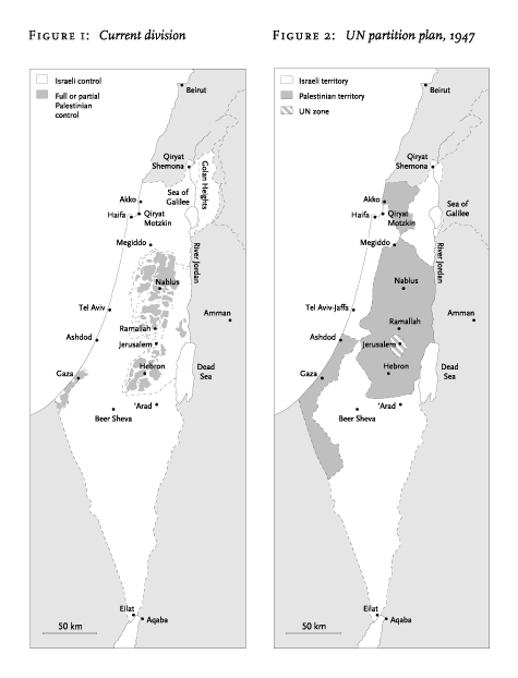
Neither the division proposed in the stillborn partition project of Resolution 181 nor the pre-1967 map of the territories occupied by Israel, acknowledged by Resolution 242, meets these requirements. In both cases, the State of Palestine would consist of a constellation of ‘scattered limbs’. In order for these to communicate with each other by road—still the most common, everyday method of travel—‘Danzig corridors’ through Israel would have to be created: two, in the first case, and one in the second. The sorry memory of this product of the Versailles Treaty can hardly encourage its repetition. On quite a different scale, French peasant farmers are quite aware of the bickering and inconvenience caused by the easements entailed on their lands, especially over rights of way—the origin of innumerable conflicts, to this day. The UN resolutions were formulated according to the logic of the conference chamber: they are scarcely compatible with realities on the ground. To stand squarely by them now would be the equivalent of making one nation a Bantustan of the other, which is completely unacceptable. Indeed, their proposals—carrying within them all the germs of war—call for the utmost caution: for the two parties to find themselves, one versus the other, in the position, to borrow a favourite image of Mao Zedong’s, of an encircled encircler, would cast grave doubt on the possibility of a just and lasting peace in the region.
Taking all these points into consideration, the only solution would seem to be the establishment of two self-contained states, each with a ‘sea view’. The latter is a matter of elementary justice: both parties can lay equally legitimate claim to access to the sea, and enclavement would be a ready source of conflicts and difficulties. One state would inevitably be the prisoner—or the hostage—of the other. The two-state solution suggested would naturally meet with serious obstacles in practice, however convincing in purely intellectual terms. Nevertheless, these problems seem less insurmountable than those attendant on the ‘scattered limbs’ approach.
At the juridical level, there is no reason why the UN should not come out in favour of such a solution. The greatest difficulties lie on a practical and human level. The existence of two such self-contained states would inevitably require changes to the present legal, territorial borders that would involve both transfers of population and exchange of land. This is the most sensitive point, at which the mind might well falter or draw back—were the alternative not the bloodshed that would be the inevitable outcome of any ‘scattered limbs’ formula. This is also why, if an agreement were reached, it would have to be implemented with the utmost generosity, caution and skill.
Transfers and exchanges of population as the result of an accord have occurred in the past. In 1923, for example, the Treaty of Lausanne which concluded the Greco-Turkish war provided for the mass repatriations of Greeks from Asia Minor and Turks from Greece. These occurred in precarious material conditions and under pressure of events. But, come what may, they were carried out. In the Israeli–Palestinian case, with both time and money available, it should be possible to do far better, especially if the operation were undertaken via the United Nations, and provided that Israel—a consolidated state with fifty years’ existence and ample resources behind it—contributed a minimum, rather than stripping what it evacuated even of trees, as it did when handing Sinai back to Egypt in 1982. The price of a viable peace, after all, is always lower than a state of war.
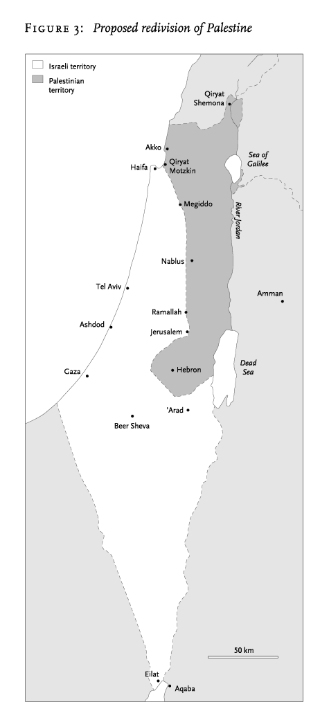
Of course, even if the material resources were to be found for an exchange of goods and populations to occur under optimal conditions, the human and moral realities of such an operation escape any diplomatic formula. Every uprooting is experienced as an exile, and every resettlement as an ordeal. So it goes without saying that the sort of reconfiguration suggested here could only be envisaged by consent, not by force. That is an additional reason for thinking that there can be no solution to the Israeli–Palestinian conflict without the involvement of the United Nations, including in the first instance the five permanent members of the Security Council. It also means that the exchanges to be considered should be kept to the minimum necessary to ensure continuous territorial space and access to the sea for both sides. Fertility of soil, ease of communications, availability of harbours, and other geographic and economic factors also need to be taken into account. The scheme sketched below (see Figure 3) is neither fixed nor final, and is only one of many possible solutions—it is offered simply to show an example of how these principles might be given reality. Its starting-point is the 1949 division of Palestine, while at the same time bearing in mind the partition proposed by the UN in 1947 which was more favourable to the Palestinians in surface area (see Figure 2). This is not to imply any particular preference between them. The purpose is simply to illustrate the possibilities of a different solution.
Sea frontage
The Israelis are at present well-endowed with access to the sea. If the Palestinians are to obtain an integrated coastline, there are only two possibilities: the Mediterranean or the Red Sea. The briefest reflection reveals the latter to be totally impractical. Under any hypothesis, the West Bank would have to furnish the nucleus of a future Palestinian state. A Red Sea frontage would require extending this by a 250-kilometre-long strip across the Negev desert, running alongside the Jordanian border, and terminating in the cul-de-sac between Aqaba and the Israeli port of Eilat. This would be no more than a highway, cut across a barren region, leading to a few kilometres of beach, gained in exchange for the Gaza Strip and a few other districts along the Jordan. Such a long appendix—of no value in itself—could be cut off or blocked by the Israelis at the least hint of conflict. On security grounds alone, therefore, any Red Sea solution can be rejected out of hand. That leaves the Mediterranean. Here there is only one real option which could fulfill the Palestinians’ legitimate need for access to the sea. To avoid any splitting of Israeli territory, the Palestinian seafront would have to be adjacent to the coastline of Israel, not included within it. The Gaza Strip clearly fails to meet the fundamental condition of territorial continuity, indispensable to both parties. What remains is the coastline to the north: running from—but not including—Haifa, up to the Lebanese border, with a decent port, Akko (once St. John of Acre) at its midpoint. This would imply that Galilee, with its sizeable Palestinian minority, would go to the State of Palestine, in order to link the West Bank to the Mediterranean. In compensation, the Gaza Strip and other lands would go to Israel, hectare for hectare. The Golan Heights would be restored to Syria, in keeping with Resolution 242.
Within this framework, a single Israeli–Palestinian border would run from west to east, starting at Qiryat Motzkin, at the foot of Haifa and Mount Carmel; crossing the plain of Emeq Yizreel and the Qishon valley to Megiddo; and then tracing a line from Megiddo to Ramallah down to Jerusalem. A sacred city for both parties, Jerusalem would be either shared or internationalized, as proposed in Resolution 181. The frontier would then follow that of the present West Bank, up to a line drawn between Ashdod and ’Arad, passing some dozen kilometres to the south-west of Hebron. A section of this tangent would become the new border, running from north-west to south-east across the Hebron salient. After this, the frontier would return to the present limits of the West Bank, down to the Dead Sea. In return for Galilee, the current West Bank would therefore cede not only the southern tip of the Hebron salient but all territories lying to the north and west of the Megiddo–Ramallah–Jerusalem line.
Guarantees of security
Resolution 242 lays down mutual security as an essential goal of a comprehensive peace settlement. From a military viewpoint, how would the proposed 250-kilometre border look? The line terminates for both sides in water, on either flank: to the west, the Mediterranean; to the east, the Dead Sea. Save around Hebron, it presents no obvious salient vulnerable to encirclement—as the Jordanian West Bank was in 1967, rapidly strangled by the IDF. True, the territory allocated to the Palestinians in the region of Hebron would form something of a pocket—albeit a rounded one. But this sector has, at its centre, the defensive advantage of the massif lying to the north and south of the town. To its east, it borders on that section of Israeli territory backing on to the Dead Sea. Thus if Israel were to threaten an attack there, a counter-offensive could be launched from the Hebron region to trap Israeli forces to the east. Overall, the advantage to one side is counterbalanced by advantage to the other—an incentive to both sides to restrict themselves to a purely defensive stance, on this part of the frontier as elsewhere.
A further military consideration is strategic depth. This was, of course, always at work in the idea of Greater Israel. Schematically, it can be conceived as the distance between the point furthest from the frontier and that closest to it. This is a somewhat arbitrary definition, but the only readily commensurable one. For the envisaged State of Palestine, it would be the distance between Qiryat Shemona and Haifa: 80 kilometres. For Israel, it would be the 200 kilometres between Eilat and the most southerly point of the Hebron salient. In reality, of course, strategic depth can extend beyond a nation’s frontiers: the notion may legitimately include any areas to its rear through which aid and allies can be summoned in time of tension. In this respect, the Palestinian state would be backed up by land: the Arab countries on its borders—Jordan, Syria and Lebanon—can reasonably be assumed to maintain friendly relations with it. That would go a good way to offsetting the fact that the coastline allocated to the State of Palestine here would lie, almost in its entirety, within range of Israel’s 155-millimetre field artillery. In return, back-up for the Israelis would come by sea. The US Sixth Fleet is permanently stationed in the Mediterranean, which is also bordered by several European countries with significant naval strength and undoubted commitment to the existence of the State of Israel: France, Spain and Italy. The US showed how rapidly it could intervene in the Yom Kippur War of 1973, delivering arms, munitions and spare parts to the IDF. In addition, the proposed Megiddo–Jerusalem border places Tel Aviv, with its harbour and its airport, just out of range of current 155-millimetre artillery shells.
Tactically, the proposed border to the north of Jerusalem would in fact give Israel much more than just the advantage of putting Tel Aviv beyond the range of modern field guns. The range of heights extending southeast from Mount Carmel affords excellent lookouts and defensive positions, and would provide good cover for the northern flank of an army facing an offensive from the Megiddo–Jerusalem line towards the Plain of Sharon and the sea. In addition, Israel would control the corniche formed by the first escarpments of the Samarian hills, a redoubtable vantage-point in times of tension, affording clear views across the entire coastal plain, and itself surrounded by a chain of elevations which could be further enhanced as observation posts, looking towards and beyond the proposed frontier. This vantage-point and its approaches could be transformed into a surveillance zone, with sufficient obstacles deployed to delay any attack long enough for a defence to be mounted. The Israelis are experts in this field. In the Yom Kippur War, their Bar Lev line on the Suez Canal served its purpose perfectly: not—whatever might have been said at the time—as an insurmountable barrier to an Egyptian advance, but as an obstruction to slow down attackers and gather forces for an Israeli defence. Since then, Israel has reinforced its Lebanese, Syrian and Jordanian frontiers with a continuous barrier of wire fencing, minefields, electronic sensors, trenches and searchlights.
At the same time, the proposed border would give the Palestinians defensive and observational vantage-points along all the crests to the north of Hebron, and to the east of the Megiddo–Ramallah–Jerusalem line. Further north, the heights stretching from Mount Tabor to Nazareth, and beyond, face those between Haifa and Megiddo on the Israeli side of the Qishon valley. So there would be nothing to prevent the Palestinians creating a parallel zone of surveillance on their side, reinforced if need be with similar defensive obstacles. The terrain there is generally very favourable for the purpose. The defensive equilibrium so created would be the best guarantee of the mutual security that both sides legitimately require.